Expansion of Meshtastic Network Across Westmoreland County
At the moment, my largest project is in attempt to implement and expand a Meshtastic network such that folks in Westmoreland county can utilize it effectively. Meshtastic is known for being great at long range communication using low cost hardware. But I live in the western part of Pennsylvania. And as it would be, we don’t have very flat land.
With that said, I think that I can utilize my skill set to help improve our area’s Meshtastic robustness. See, during my years through college, and obviously before I started my life-long career, I worked for a radio communications company on the professional side of two-way radio. (Fitting, right?) While exploring that career, I became a tower climber. Excitedly, because despite my fear of heights (oh yeah, still fearful of height) I was ambitious to try out something new that would kill two birds with one stone. Sate my curiosity in high altitude broadcasting, and feed my addiction to adrenaline.
So with my existing skill set and connections I have made throughout life, I think I can leverage these things to get some Meshtastic equipment in higher altitudes 🙂
Well guess what? I’ve already started.
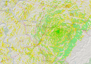
That’s right! In addition to the node at my home near Westmoreland Hospital, I have installed a Meshtastic node up on the hill near Speedway on Rt.30. This node provides coverage from the eastern-facing hills of Greensburg, to some parts as far as North Versailles! At least, that’s as far as I have been able to prove. There’s a fella over that way who suddenly came online minutes after installing the node.

If you’ve never seen a map that looks like this before, let me break it down for you. We use colors to indicate the signal strength expected at each location on the map. Green means the signal is good or greater than -90 dBm. Yellow indicates the signal is getting poor, or between -90 and -130 dBm. If the signal is less than -130 dBm, (the cusp of most Meshtastic receiver’s minimum signal) the map has no color. So it looks based upon this map that we should have pretty excellent coverage near APRA, and also make the hop into Greensburg. There are some fringes in the greater altitudes, so that’s nice! But we’re completely missing Jeanette and Irwin except for some very small areas within. Looks like I have some work to do!
The software I use to generate maps like above is called RadioMobile. It can be found at VE2DBE‘s website. It’s free and super powerful!
So, according to my propagation survey, it’s quite impressive someone from North Versailles is able to hit this node. Then again, I intentionally draw these maps on a ‘worst-case scenario’ configuration. As such, I tend to be a little more surprised than disappointed when I do finally get a radio in place and see it’s performance first hand. Still, it ends up being accurate enough to get a pretty solid idea of performance. Thanks, VE2DBE!
If you made it this far, thanks for reading! I have a lot more coming down the pipe.
Filed under: Project - @ April 29, 2024 6:02 am
